Map of San Francisco and Poro

Map of San Francisco and Poro

The graphic image below is the map of San Francisco and Poro. Mostly, you can find beach resorts in San Franciso.

Map courtesy of Google.com

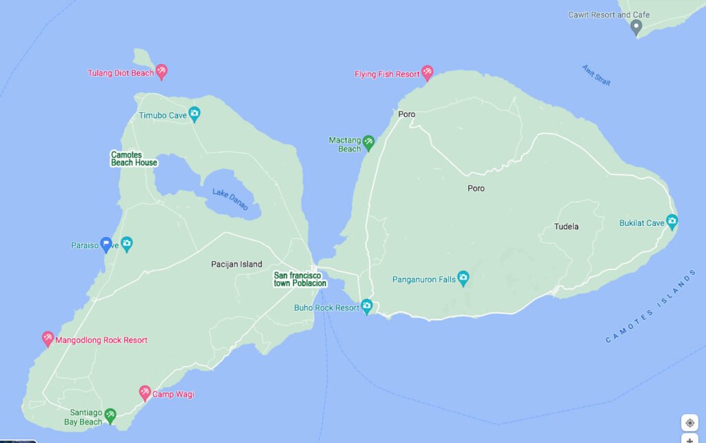
Pacijan Island (San Francisco)

  • Consuelo port is located just south of Paraiso cave. The line going to San Francisco town Poblacion is the road map.
  • Mangodlong Rock Resort is South west.
  • Camotes Beach Resort is North west.
  • Santiago Bay Beach is south of San Francisco Island.
  • Lake Danao, Timubo Cave is North.
  • Tulang Diyot is North west.

Poro Island

  • Pangunaron falls is south
  • Bukilat cave is east
  • Boho Rock Resort is just near the San Francisco Poblacion.

You can also find the map in Google. click here.

Click to rate this post!
[Total: 0 Average: 0]

You may also like

A backpacker guide on Camotes Islands

A backpacker guide on Camotes Islands

This backpacker guide on Camotes Island is an ideal way to explore the island and immerse yourself in the local...

Camotes “DIY” the path less traveled

Camotes “DIY” the path less traveled

If you’re planning a trip to Camotes Island, you may want to consider a do-it-yourself (DIY) itinerary. A DIY itinerary...

Top tourist attractions in Camotes Islands 2023

Top tourist attractions in Camotes Islands 2023

Camotes Islands is a hidden gem of the Philippines, consisting of four islands – Poro, Pacijan, Ponson, and Tulang. With...

Things to do in Camotes Islands 2023

Things to do in Camotes Islands 2023

Camotes Islands, located in the Central Visayas region of the Philippines, is a beautiful destination that offers a mix of...

Back to Top